Ashe County is located in the Northwest corner of North Carolina. Named for the Revolutionary patriot and NC govenor, Samuel Ashe, Ashe county was formed in 1799 from the North side and North West corner of Wilkes County. The county seat is Jefferson, founded in 1803, which was named after the then-current president Thomas Jefferson. Later, in 1849, Ashe County gave up its South West border to help create Watagua County. In 1859, it gave up part of its Northeast section to create Allegheny County. Since then, the boundaries have not changed. Ashe County was one a claimed by the state of Franklin (now Tennessee).
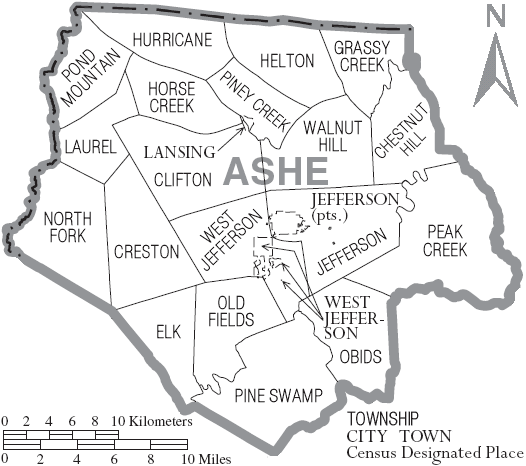
Ashe county includes 3 incorporated towns, 19 townships, 18 unincorporated towns.
Some of the townships and unincorporated towns overlap. Below are the lists for towns
(3), townships (19 - many in the map above), and unincorporated communities in Ashe
County (18). Additional information about each location comes from different sources.
Please see the end of the page
for a list of sources
Towns
Jefferson - Founded in 1799 and incorporated 1803; named for Thomas Jefferson; originally called Jeffersonton and designated as the county seat in 1799
Lansing - Incorporated May 16, 1928; occupies less than 1/2 a square mile of land
West Jefferson - Incorporated in 1915; West Jefferson was a major stop along the Norfolk and Western Railroad; named for its location in proximity to Jefferson
Townships
Chestnut Hill - NE part of the county
Clifton - Central part of Ashe
Creston - post office established 1830 as North Folk and changed the name to Creston in 1882 due to its location near the crest of the moutains
Elk -
Grassy Creek - NE corner
Helton - iron forges here from 1807-1857
Horse Creek -
Hurricane -
Jefferson - see above in "Towns"
Laurel -
North Fork -
Obids -
Old Fields - named for the military grounds used for mustering and drills during the Revolutionary War by Benjamin Cleveland
Peak Creek -
Pine Swamp -
Piney Creek -
Pond Mountain -
Walnut Hill -
West Jefferson - see above in "Towns"
Unincorporated or Inactive Communities
Beaver Creek
Bina - originally named Berlin, but name changed during World War I
Clifton - see above in "Townships"
Comet
Creston - see above in "Townships"
Crumpler - named for Civil War Major Thomas Newton Crumpler who died of wounds received during war; popular retreat in late 1800s and early 1900s because of a spring discovered in 1885 and another All Healing Springs nearby
Fig
Fleetwood -
Glendale Springs -
Grassy Creek - see above in "Townships"
Grayson -
Helton - see above in "Townships"
Parker -
Scottville - originally known as Flint Hill and settled around 1830; name changed around 1855 when a post office was established; believed to be named after respected citizen Mrs. Scott who died in 1856; post office closed in 1954
Sturgills - named for Sherriff B. Sturgills; post office operated 1887-1953
Todd - incorporated 1915, but not now active; county line changed so now a part of Watauga County; Used to be known as Elk X Roads when a post office was established in 1837, but changed to Todd in 1882
Warrensville - Incorporated 1931, but not now active; settled 1826 as Buffalo Creek, name changed for name of owner of first gristmill and sawmill
Sources
Above information gleaned from a variety of sources, including the following:
Powell, William S. Encyclopedia of North Carolina. Chapel Hill : University of North Carolina Press, 2006.
Powell, William S. The North Carolina gazetteer. Chapel Hill : University of North Carolina Press, c1968.